


NISAR satellite sends first detailed radar images of Earth’s surface
On September 25, NASA reported that the NISAR (NASA-ISRO Synthetic Aperture Radar) Earth-observing radar satellite’s first images of our planet’s surface are in, and they offer a glimpse of things to come as the joint mission between NASA and ISRO (Indian Space Research Organisation) approaches full science operations later this year.
Images from the spacecraft, which was launched by ISRO on July 30, display the level of detail with which NISAR scans Earth to provide unique, actionable information to decision-makers in a diverse range of areas, including disaster response, infrastructure monitoring, and agricultural management.
~
~
“By understanding how our home planet works, we can produce models and analysis of how other planets in our solar system and beyond work as we prepare to send humanity on an epic journey back to the Moon and onward to Mars,” said NASA Associate Administrator Amit Kshatriya. “The successful capture of these first images from NISAR is a remarkable example of how partnership and collaboration between two nations, on opposite sides of the world, can achieve great things together for the benefit of all.”
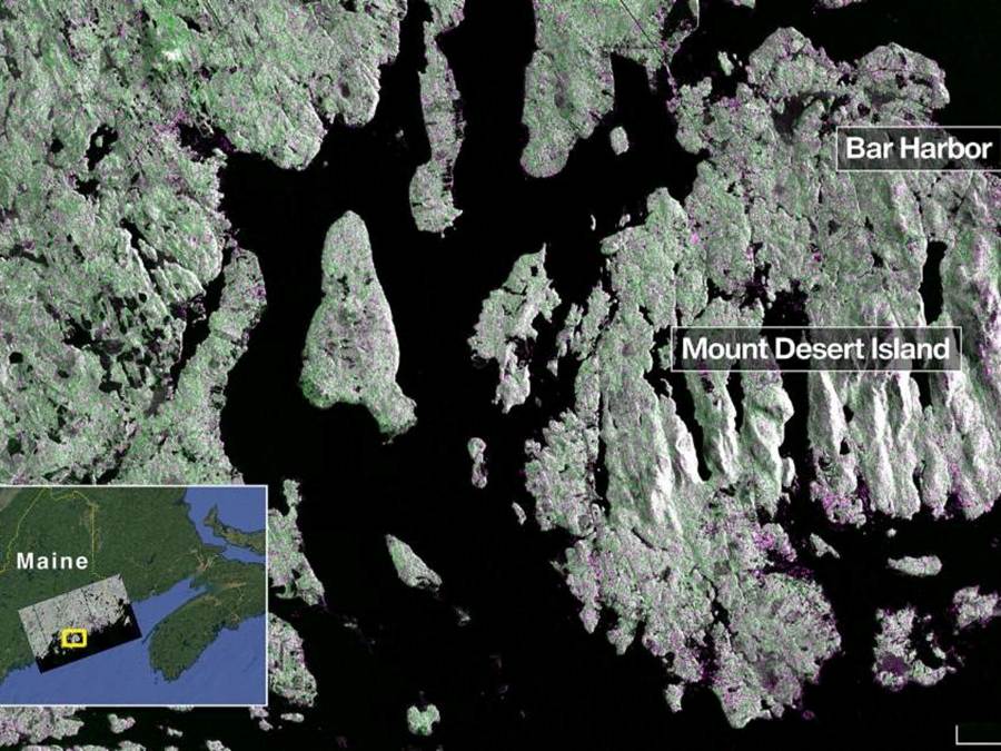
On August 21, the satellite’s L-band synthetic aperture radar (SAR) system, which was provided by NASA’s Jet Propulsion Laboratory in Southern California, captured Mount Desert Island on the Maine coast. Dark areas represent water, while green areas are forest, and magenta areas are hard or regular surfaces, such as bare ground and buildings. The L-band radar system can resolve objects as small as 15 feet (5 meters), enabling the image to display narrow waterways cutting across the island, as well as the islets dotting the waters around it.
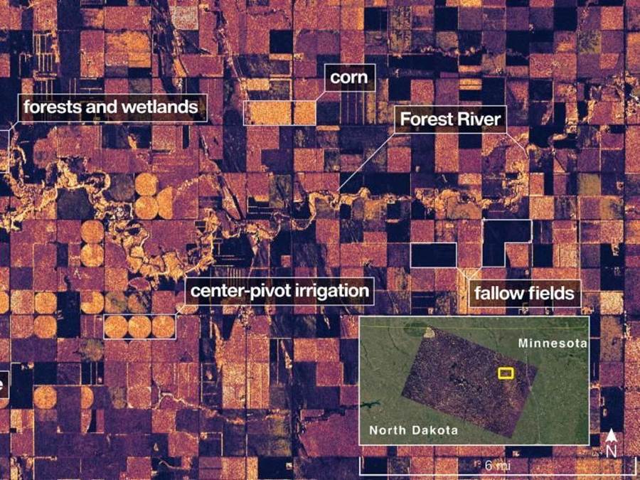
Then, on August 23, the L-band SAR captured data of a portion of northeastern North Dakota straddling Grand Forks and Walsh counties. The image shows forests and wetlands on the banks of the Forest River passing through the center of the frame from west to east and farmland to the north and south. The dark agricultural plots show fallow fields, while the lighter colors represent the presence of pasture or crops, such as soybean and corn. Circular patterns indicate the use of center-pivot irrigation.
~
The images demonstrate how the L-band SAR can discern what type of land cover — low-lying vegetation, trees, and human structures — is present in each area. This capability is vital both for monitoring the gain and loss of forest and wetland ecosystems, as well as for tracking the progress of crops through growing seasons around the world.
“These initial images are just a preview of the hard-hitting science that NISAR will produce — data and insights that will enable scientists to study Earth’s changing land and ice surfaces in unprecedented detail while equipping decision-makers to respond to natural disasters and other challenges,” said Nicky Fox, associate administrator, Science Mission Directorate at NASA Headquarters in Washington. “They are also a testament to the years of hard work of hundreds of scientists and engineers from both sides of the world to build an observatory with the most advanced radar system ever launched by NASA and ISRO.”
The L-band system uses a 10-inch (25-centimeter) wavelength that enables its signal to penetrate forest canopies and measure soil moisture and motion of ice surfaces and land down to fractions of an inch, which is a key measurement in understanding how the land surface moves before, during, and after earthquakes, volcanic eruptions, and landslides.
The preliminary L-band images are an example of what the mission team will be able to produce when the science phase begins in November. The satellite was raised into its operational 464-mile (747-kilometer) orbit in mid-September.
The NISAR mission also includes an S-band radar, provided by ISRO’s Space Applications Centre, that uses a 4-inch (10-centimeter) microwave signal that is more sensitive to small vegetation, making it effective at monitoring certain types of agriculture and grassland ecosystems.
The spacecraft is the first to carry both L- and S-band radars. The satellite will monitor Earth’s land and ice surfaces twice every 12 days, collecting data using the spacecraft’s drum-shaped antenna reflector, which measures 39 feet (12 meters) wide — the largest NASA has ever sent into space.
The NISAR mission is a partnership between NASA and ISRO spanning years of technical and programmatic collaboration. The successful launch and deployment of NISAR builds on a strong heritage of cooperation between the United States and India in space.
The Space Applications Centre provided the mission’s S-band SAR. The U R Rao Satellite Centre provided the spacecraft bus. The launch vehicle was provided by Vikram Sarabhai Space Centre, and launch services were through Satish Dhawan Space Centre. Key operations, including boom and radar antenna reflector deployment, are now being executed and monitored by the ISRO Telemetry, Tracking and Command Network’s global system of ground stations.
Managed by Caltech in Pasadena, NASA JPL leads the U.S. component of the project. In addition to the L-band SAR, reflector, and boom, JPL also provided the high-rate communication subsystem for science data, a solid-state data recorder, and payload data subsystem. NASA’s Goddard Space Flight Center in Greenbelt, Maryland, manages the Near Space Network, which receives NISAR’s L-band data.
Video:
~
(Source: NASA)
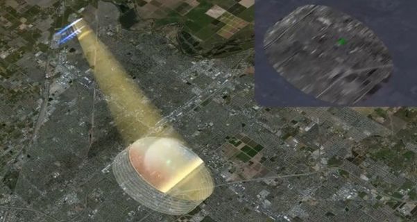
(Cover image: “The Magic of SAR” – NISAR will be the first radar of its kind in space to systematically map Earth, using two different radar frequencies (L-band and S-band) to measure changes of our planet’s surface, including movements as small as centimeter. Synthetic aperture radar (SAR) refers to a technique for producing fine-resolution images from a resolution-limited radar system. Image credit: NASA
Posted by Richard Webster, Ace News Today
Follow Richard on Facebook, Twitter & Instagram