


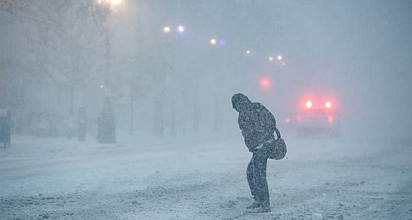
Massive March storm slams U.S., triggering tornado threats, historic blizzards, nationwide travel chaos
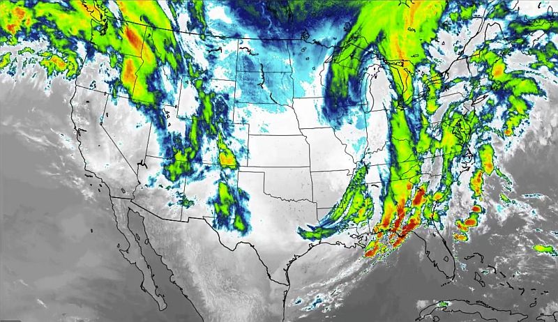
(The historic blizzard/winter storm continues to move eastward across the U.S and produce moderate to heavy snowfall/blizzard conditions and significant to dangerous severe storms that have been producing or are currently producing or capable of producing tornadoes (some strong and dangerous), destructive winds … Image credit: X)
A powerful multi-day March storm sweeping across the United States has unleashed a rare and dangerous mix of tornado threats, historic blizzard conditions and massive travel disruptions, affecting tens of millions of Americans from the Gulf Coast to the Great Lakes and the East Coast.
As of Monday morning, more than 17,700 U.S. flights had been disrupted since Sunday, according to FlightAware, creating a cascading backlog expected to impact travelers through at least Tuesday. At least 1,800 flights had already been canceled nationwide, with thousands more delayed, as major airline hubs including Chicago O’Hare, Minneapolis–St. Paul, and New York-area airports struggled with the severe weather during the busy spring break travel season.
The sprawling storm system has produced dramatically different — and equally dangerous — conditions across the country.
In the Upper Midwest and Great Lakes, blizzard conditions dumped one to two feet of snow, with some areas reporting 25 to 26 inches already. Green Bay, Wisconsin recorded 14.8 inches in a single day — its snowiest day in 137 years — while parts of Michigan’s Upper Peninsula have seen snowfall totals exceeding two feet with more expected.
Powerful winds have created near-whiteout conditions in some areas, forcing the closure of major routes including Interstate 80 in Iowa and sections of I-35, while the Mackinac Bridge in Michigan was temporarily shut down. Officials warned that many roads remain dangerous or impassable, and several states issued travel advisories.
At the same time, the storm’s southern flank is fueling a rare high-end severe weather outbreak across the Southeast and Mid-Atlantic. The Storm Prediction Center placed nearly 13 million people under a Level 4 out of 5 severe weather risk, with forecasters warning of tornadoes, damaging winds up to 75–80 mph, large hail and heavy rain from the Carolinas through Virginia and into the Washington, D.C. region.
The widespread weather emergency has also left nearly half a million customers without power across multiple states, while schools across parts of Washington, D.C., Maryland, Virginia, North Carolina, South Carolina and Georgia canceled classes or shifted to remote learning.
Meteorologists say the storm is unusual because of its simultaneous impacts across multiple regions, delivering severe thunderstorms in the South while burying the Midwest under historic snowfall — a combination rarely seen in mid-March.
Forecasters expect the system to continue pushing eastward through Monday, bringing severe weather to the East Coast before moving offshore by Tuesday. However, flight delays, airport congestion, power outages and hazardous travel conditions could persist well into the week as communities dig out from one of the season’s most disruptive storms.
For more on this multi-state and potentially devastating storm – see the video below.
~
(Sources: CBS News, Travel Pirates, Fox Weather, National Advisory)
Posted by Richard Webster, Ace News Today
Follow Richard on Facebook, Twitter & Instagram